The era of digital transformation accelerates the use of geospatial technology, big data and artificial intelligence thereby triggering the development of geospatial analysis for development planning, policy-making, and decision-making.
Data-based solutions, location, and artificial intelligence (AI) or known as geospatial artificial intelligence (GeoAI) is a problem-solving approach using geographic information systems combined with AI, including machine learning and deep learning.
President Joko Widodo currently at the commemoration of the Geospatial Information Agency, reiterated that a strong country is a country that controls data, information, and geospatial technology.
Country Manager of Esri Indonesia Christanto Yanuar said that the use of GeoAI is increasingly being used in various industrial sectors.
“There is much more that can be done with GeoAI technology, such as marketing planning, location selection, price optimization, product selection, workflow automation to provide fast and accurate service and decision making.”
On this event, Ade Komara, Head of the Center for Topographical and Toponym Mapping at the Geospatial Information Agency, mentioned the importance of accelerating the provision of large-scale base maps as the main infrastructure that is used as a basis or reference when other institutions or organizations make thematic maps according to their individual needs.
Ade emphasized that there are some challenges in accelerating the provision of a detailed scale base map. It is necessary to find economical, fast and good technologies and methods that meet the quality requirements.
“GeoAI is a technology that meets these three prerequisites. Based on our study, automation using AI can save more than 79% of data processing time compared to manual processing,” he said.
Meanwhile, Nazib Faizal, Head of the Data and Information Center of the Ministry of Public Works and Public Housing (PUPR), explained that the use of GeoAI is used by the Ministry of PUPR to speed up decision-making and as a consideration in making policies.
“By using quite a lot of parameters and data, so that people can get the maximum outcome,” he said. Nazib gave an example of one of the implementations of GeoAI by modeling traffic trends, detecting vehicle license plates for Multi Lane Free Flow and analyzing disaster trends.
The same thing was explained by Prayogi Setyo Pratomo, Head of the Traffic and Security Department of Astra Tol Cipali. Prayogi said that in efforts to modernize asset management for national highway infrastructure, the use of CCVT, IoT, machine learning and ArcGIS software can provide visualization to evaluate the condition of sidewalks, bridges, and road features while monitoring planning, maintenance, operations, and investment.
From the plantation sector, Haryo Sagoro, Head of GIS from Wilmar International Plantation, shared a story from Wilmar’s oil palm plantations.
“With GeoAI technology, plant health can be monitored and mitigated. In addition, if there is an infection, the oil palm trees can be handled immediately to minimize the spread which will cause more losses,” he said.
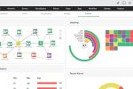
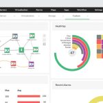
The ability to detect objects, find patterns and make predictions, can be seen and accessed through the dashboard. Esri Indonesia together with BNPB built a disaster management dashboard to identify the coordinates of the most severely affected to determine the priority scale of assistance, such as the recent earthquake in Cianjur.
Esri Indonesia is part of Esri Global which is a pioneer as well as a provider of software and solutions based on geographic information systems.